PREVIOUS | NEXT | HERITAGE TRAIL HOME
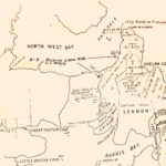
| To your front and left is the site of Kelly’s original 1818 farm. In addition to the farm cottage, by 1829 there is a ‘barn, a servant’s house, a storehouse’, and ‘an enclosed garden well’, along with a new ‘dwelling house’. In 1839 we learn of ‘Men’s Huts’ and a garden ‘well stocked with Fruit Trees’. We know this because Kelly’s pursuit of additional Crown lands sees ‘improvements’ made to existing holdings that are detailed in the colonial press. Kelly eventually holds title to over 2000 acres of North Bruny, his domain extending down the Channel to what is now Quarantine Bay and south-east to One Tree Point, though only 80 acres is ‘under cultivation’ by 1829.
Evidence of farm buildings and farming operations remains, though much awaits identification. Possibly because it was lightly timbered and easily reached from Hobart Town, this country is much utilised by Europeans before Kelly arrives. Midden shell for lime, wood for fuel and timber, and game meat are all taken. The land on which you now stand is regarded as a commons, and Kelly initially suffers depredation from stock duffers, fodder thieves and wood hookers. He advertises in the Hobart Town Gazette, threatening to ‘proƒecute to the utmoƒt Rigor of the Law any Perƒons… falling or removing Timber or cutting Graƒs…’ Though the farm is often labelled ‘Elizabeth Farm’, its only mention as such is in one of these advertisements – Kelly more usually designates it ‘Cape-get-out’ or ‘Lagoon Point’, and by 1825 the name ‘Kelly’s Farm’ is firmly in place. The farm’s vulnerability is emphasised in 1850, when a serious robbery occurs. According to the Hobart Town Courier, ‘Kelly and his man’ (who may have been John Merrison – Kelly’s ‘faithful servant’) are locked up in an early morning home invasion and robbed of £40, by a large gang, all of whom, except the leader, have blackened their faces. Kelly also meets resistance from Aborigines, understandable given the location of the farm at the very point of their crossing to and from the island. In 1820 he describes displaced Aborigines from North-West Bay and the Huon River as ‘hostile’, and the farm is raided at least twice – in 1825, by ‘a large body of aborigines led by a one-armed woman named Nelson’, and in 1828 by another large party from ‘the Port Davey Mob’. But Kelly is known to frequently remonstrate with his employees over their treatment of Aboriginal women, and Trucanini and other Aborigines spend time at his farm. The farm raises livestock, fruit, vegetables and grain, and is part of an efficiently integrated operation to supply Kelly’s ships and whaling stations. It is also a profitable base for his piloting activities. He often brings much-welcomed fresh produce aboard when guiding ships through the estuary to town.
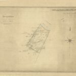
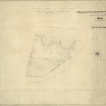
Further Reading and image sources Ranson, D. and Lehman, G. (2015), ‘Aboriginal Heritage Significance of Kelly’s Point (Dennes Point), Bruny Island’, unpublished report for Friends of North Bruny. Kostaglou, P. (2014), Archaeological Survey – Kelly’s Farm Section, Cap de la Sortie: Final Report, Tas Archaeological Services, Hobart (Report for Friends of North Bruny). The chart showing Kelly’s original grant was sourced from a report prepared for Friends of North Bruny by TasArc: Archaeological Survey, Kelly’s Farm Section, Cape de la Sortie, North Bruny Island. This document, prepared to inform the planning of the Dennes Point Heritage Trail provides further background reading about the archaeological investigations carried out on the Kelly’s Farm site and their findings. Many newspaper articles, including those referred to in this article, can be found on the National Library of Australia’s Trove website. The two plans shown to the right, of Kelly’s properties in the vicinity of Shelah Cove (Bull Bay), are from the Tasmanian Archives and Heritage Office. They are from ‘Series: County Maps, 1810 – 1959 (AF396)’. In order of appearance, they are recorded as:
The image of Woodlands is from the Tasmanian Archives series: Miscellaneous Collection of Photographs. 1860 – 1992, ref. PH30. The image of Trucanini is held in the WL Crowther Library, Tasmanian Archives. |
ListenGallery(Click to enlarge images)


|